Places of interest
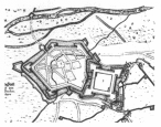
The town and fortress of Jülich were designed on the drawing board: after the great fire of 1547 almost the only houses left standing were in Kleine Rurstrasse. The Italian masterbuilder, Alessandro Pasqualini, famous since 1530 as an outstanding military and civilian architect in the Netherlands, was therefore able to realize his conception, on behalf of the Duke, of an ideal Renaissance town and fortress: straight broad streets aligned with the pentagon of the town fortress surrounding them, the fifth corner being formed by the citadel (drawing M. Merian, about 1630) This ground plan, indicated on the town map and still recognizable on the aerial photograph on the title page, remains unchanged to the present day in all essential features.
The courses of streets originating from even earlier periods are represented by the present Römerstrasse and lower Kleine Rurstrasse corresponding to the Roman main road as well as - from the early Middle Ages - the arc formed by Raderstrasse and Kapuzinerstrasse. The medieval marketplace was located in this region.
As an impressive centrepiece to the town, Pasqualini constructed a new marketplace from 1547, with the same location and size as today, on the site of the former Roman castellum.
In the first century AD the Roman main road from Cologne-Jülich-Maastricht to Boulogne-sur-Mer on the channel coast ran diagonally across the present market square - coming from the direction of Römerstrasse - about 3 metres below the current level, and its route is now indicated by a line of grey paving stones. At the old town hall it crossed a marshy region or stream bed and continued under Kleine Rurstrasse and the Rur Gate (Hexenturm) to the Rur crossing. The civilian settlement (vicus) of Juliacum arose along this axis on a slight projection of the edge of the valley reaching almost up tho the Rur and standing above flood level due to expansion of the Roman station in the late 1st century BC. An original cross-section of the Roman main road, displaying its two-thousand-year history, can be viewed in the local history museum (Stadtgeschichtliches Museum) next to the Hexenturm.
The old town hall was rebuilt in 1953 according to plans by Prof. René v. Schöfer, Aachen, on the site of the 1781 baroque building which had been destroyed in the war. After the reorganization of local government in 1972, it now only accommodates a few departments of the municipal administration.
The elevated position of the market square, up to almost 5 metres above the original ground level and the gradient of most of the adjacent streets, can be explained by the deposition of rubble over the centuries.
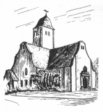
(1) Propsteikirche (Provost's Church)
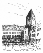
The antiquity of the church is demonstrated by the remains of Roman walls beneath it and its orientation based on the ground plan of the late Roman castellum. It was probably built onto the wall of the castellum, upon the remains of which the walls of the nave and the sacristy now stand (on the side towards Stiftsherrenstrasse). The church was the centre of the Deanery of Jülich encompassing in the 13th century 71 churches in the Jülich, Düren, Eschweiler and Geilenkirchen districts as well as in Burtscheid, a suburb of Aachen. Outside this church Saint Bernhard of Clairvaux called on the faithful in 1147 to join the Second Crusade. Knights from Jülich followed this call to the Holy Land for several decades; Count William III of Jülich died in Egypt in 1219.
The Romanesque entrance and the lower tower storeys date from the 12th century, the remaining sections were rebuilt after severe damage in the Second World War. Next to the left side entrance, embedded into the wall is the narrow end of a Roman votive altar decorated with a horn of plenty with pine cones, fruit and flowers.
The southeast side of the Propsteikirche still marks the former course of the late Roman castellum wall, which with 12-14 towers covered the area around the present church and market square in a polygon about 140 m in diameter. Grey flagstones running diagonally across Marktstrasse, Kleine Rurstrasse, Düsseldorfer Strasse and Kölnstrasse mark the position of the castellum foundations discovered under the streets by excavations. Raids by the Germanic tribes since the third century made it necessary to construct the castellum in the early fourth century.
The northwest corner of the castellum, which was used well into the Middle Ages, was probably in the region of an elevated terrace (wall, mound of earth) in a backyard between upper Kleine Rurstrasse and Raderstrasse. The first castle of the counts of Jülich was sited here; it was destroyed in 1278.
A Roman "sarcophagus" (a) (for funeral urns discovered in Kirchberg) and a stone from the Roman period (b) decorated with a Maleander frieze (found in the region of the castellum wall in Marktstrasse) are displayed at Schlossplatz and Bahnhofstrasse respectively.
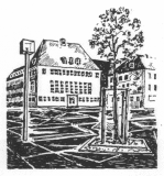
(4), (5), Schwanenteich, New Town Hall
The Schwanenteich (swanery), originally a fishpond and watering place for horses surrounded by grassy banks for bleaching laundry, is situated outside the former fortification ring. It is flanked by the buildings of the district savings bank and the new town hall erected in 1952 on the site of the Prussian assembly house of the estates (district administrator's office), destroyed in the war, as the headquarters of the administration for the district of Jülich, which lost its autonomy in 1972. After the reorganization of local government the building was acquired by the town and now houses the municipal administration.
Next to the new town hall are parts of the town bastion St. Eleonora c) blown up in 1860; there is a pond at the rear of these ruins, a remnant of the former moat.
This is the only bastion, surviving at least in part, belonging to Pasqualini's town fortress which is still accessible. Above ground only a mound with a few walls at the side can be seen, but below ground the casemates are completely preserved. They are used as business premises and are thus generally accessible during opening hours.
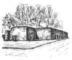
The pentagonal town fortress had bastions like this in four corners - connected to each other by straight ramparts 8 m high and up to 22 m thick - and the fifth corner was formed by the citadel. The other town bastions were known as St. Eleonora (c), St. Sebastianus (d) and St. Franziskus (e). The external contours of the fortress can still be followed in the course of Poststrasse and Bauhofstrasse, the streets Am Aachener Tor, Schützenstrasse and Schirmerstrasse (remains of wall (f) at the St. Sebastianus bastion, assignment unlear); they are furthermore also visible at the depressions (h) (formerly ditches) and mounds (i) (formerly embankments) in the park sited in a bend of the River Ellbach, as indeed along the whole course in this area, by means of which the approaches could be flooded for defence purposes.
The barrel vaults (g) of a powder mill from the Prussian period (situated in front of the former town wall along the present Schirmerstrasse) are used as a discotheque.
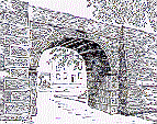
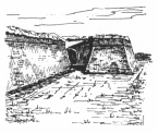
Remains of a gate in the town fortress with the adjacent section of the town wall connecting it to the St. Jakob bastion in front of a partly filled-in ditch once 4.5 m deep and 30 m wide; completed in 1548, it was the first Renaissance town gate in the Rhineland. Only the outer gateway arch still remains, the interior arch and gatehouse were torn down in 1860. Until then all passenger and goods traffic towards the west had to pass through this narrow gate.
This was the town gate (Rur Gate) of Jülich's medieval town wall until 1547, of which a small section still remains in a backyard (k) between Poststrasse and Stiftsherrenstrasse, accessable from there. It was built in the early 14th century after the capture and destruction of Jülich by Archbishop Siegfried of Cologne in 1278, which revealed the inadequacy of the previous fortifications; wall thickness up to 2.30m, street level now about 1 m above the original state. A small projection for the privy can be seen on the northern tower next to the former adjacent town wall, which was 1.70 m thick.
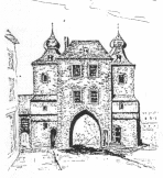
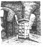
The Hexenturm had four levels of defence, including the originally flat, crenellated roof. The present shape of the roof dates from the 17th century. After demolition of the town wall at the beginning of the modern period, the Hexenturm was used as a jail and torture chamber for the main and criminal courts of the duchy. Witch hunts were extremely rare in Jülich; as early as 1563, the Duke's personal physician, Johannes Weyer, opposed the obsessive belief in witches widespread in Europe at that time with his book "De praestigiis daemonum", which was immediately placed on the Index.
Two stones originating from Roman tombs (late first century AD) are incorporated into the outer masonry on the town side: one of them has a representation of a funeral repast and the other a man wearing a toga (illustrating his status as a Roman citizen).
Jülich's local history museum (Stadtgeschichtliches Museum) with an interesting permanent collection an also special exhibitions is housed in the "Kulturhaus am Hexenturm", whose west front reflects the medieval town wall in architecture and course.
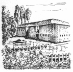
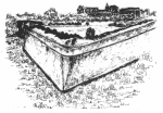
Occupied since 1794 and French national territory since 1801, Jülich was to be significantly reinforced as a main fortification on France's eastern boundary: a bridgehead (built 1799-1808) and the Fort Napoleon on the Merscher Höhe (started in 1804, not completed) were intended to combat the increased artillery range. Emperor Napoleon I inspected the construction work in 1804 and 1811, and personally laid the foundation stone at the Merscher Höhe (on the road to Düsseldorf).
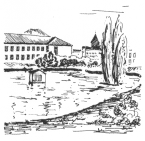
The mighty bridgehead (construction costs at that time 1.66 million francs) is 800 m in length (now divided in two by the road to Aachen) and 300 m wide. The front structure of the fortification (accessible during guided tours) has casemates throughout and, especially in the south bastion, built-on covered gun emplacements; the separate powder magazine (l) was built in 1806). The ramparts (m) beyond the moat, the major part of which is still filled with water, are now covered by trees and only traces of the outer ditches are visible. Both these areas and also the glacis (open approaches) are now used by the Bridgehead Zoo; its popular park-like grounds exhibiting largeley native animal species.
(10) Synagogue, Commemorative Plaque and Memorial
A plaque in the street An der Synagoge commemorates the Jewish place of worship (erected 1862), desecrated by the National Socialists in 1938 and finally destroyed by air raids in 1944. The earliest mention of a synagogue in Jülich dates from 1348; the first indication of Jews in the Jülich district is given by the Jews Privilege granted to Count William IV of Jülich in 1226 by King Henry VII (licence for granting protection to Jews on payment of considerable fees). An old Jewish cemetery (used from 1816 to 1941) is located in the street "An der Aachener Straße".
Jews must have lived in the Jülich district since at least 1237 and from 1324 also in the town of Jülich. They enriched culture and stimulated trade in the town and the Jülich district for centuries, but Nazi barbarism against Jews and Judaism put a terrible end to this period in the middle of the 20th century. Jews were deprived of their rights, harassed, persecuted, expelled, and deported because of their faith. According to the book "entrechtet - entwurzelt – ermordet", almost 370 of them were murdered.
Since 1996 the street name "An der Synagoge" has commemorated the former centre of the Jewish congregation. In 2001, a memorial was erected on Propst-Bechte-Platz in memory of the murdered Jews of the Jülich district (between (B) and (N)).
Protestant Church (11)
The building dating from 1910 (neobaroque, Art Nouveau) was rebuilt in 1950 after having been severely damaged in the war. Protestants are first mentioned in the Jülich area in 1577; from 1610 there was a Lutheran and a reformed congregation. After Jülich was occupied by Spanish troops in 1628, both communities had their place of worship taken from them and only after the religious settlement of 1677 were they permitted to build a church "outside the town". The gateway of the 1745 church now serves as the entrance ( n) to the former Protestant cemetery on Linnicher Strasse.
The Citadel Fortress and Palace
After 1500 the medieval town walls no longer provided any protection against the newly developed cannon. The new gunpowder weapons easily breached the vertical walls, whereas there was no room to deploy them for defence purposes on the narrow crest of the wall. Furthermore, the convex shape of the ring of walls hindered attempts to bombard the attackers in the direct approaches to the fortifications. The answer was a fortress with a polygonal ground plan incorporating bastions and straight walls designed on engineering principles permitting all-round defence without any "dead angles". These new fortifications, developed in Italy, were realized for the first time in Germany by Alessandro Pasqualini in Jülich from 1548 onwards under Duke William V, representing both modern fortifications and also with the ducal palace the start and at the same time a high point of Italian Renaissance architecture in the Rhineland.
The major feature of the Jülich fortress was the almost square citadel. Built in the north of the town, its area of 9 hectares was greater than the entire town had previously been. The distance between the outer corners of the moat measures 300 - 380 m, the parts are 35 - 43 m thick and the moat 33 m wide. The total length of the walls is 2.2 km with a height of 12.5 m. The rampart structures and bastions contain extensive casemates and tunnels, some of which may be viewed during guided tours.
Access to the citadel from the town side is gained via a the "Pasqualini Bridge" (o) constructed by means of modern technology in 1993 on the remains of the old bridgepipers. A glance to the left and right reveals the defence plan. Cannons were positioned in the cannon yards behind the sloping flanks of the bastions so that all attackers, even those in front of the opposite bastion, were within range. The water in the moat in front of the ramparts (curtains) and bastions reached, at maximum, up to the cornice of the natural-stone pedestal.
The artillery on the ramparts and the bastions the size of football pitches ensured that the attackers could already be combated in the approaches to the moat.
At the moment it is difficult and indeed sometimes almost impossible to view the bastions due to the plant cover, renovation work, school activities and warning signs. The St. Johannes Bastion (13) can be reached through a tunnel (postern) next to the caretaker's house. It affords a view from the upper level of defences towards the south front fortifications and the bastion opposite with its cannon yards and also towards the town. In the centre of the bastion there is a powder magazine now excellently restored dating from the Napoleonic period. The bastion was hit by two heavy bombs in the Second World War which penetrated down to the casemates at the level of the moat; one bomb crater has been cleared and the structure of the ramparts can be seen on the inside. A tour of the upper ramparts and - as far as they are accessible - the St. Salvator (14), Marianne (15) and Wilhelmus (16) bastions also offers interesting views.
 Im Innenhof der Zitadelle stand das vierflügelige, herzogliche Schloß mit 73 m Seitenlänge; das jetzige Schulgebäude ist auf seinem eindrucksvollen The ducal palace with four wings and a side length of 73 m stood in the inner courtyard of the citadel fortress; the present school building was erected on the impressive basement construction with numerous barrel vaults (accessible in parts during tours). The east wing with the architecturally particularly important chapel and the north wing up to the original gate to the palace courtyard have been faithfully restored. The entire complex suffered severe damage during the war but radical modifications had also been made before this when it was used as barracks (from about 1610 onwards). Thus for example the Renaissance loggia around the palace courtyard disappeared at an early date and in 1768 a fire made it necessary to renew the west facade of the chapel (rococo).
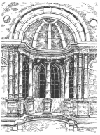
Considerable sections of the east facade of the chapel with its Renaissance architecture based on Bramantes' and Raffael's school of cathedral architecture in Rome survived the Second World War. Pasqualini's double row of columns in the upper storey the apse with a central column in its axis revealing four window openings on the inside and three outside (only visible from the inside) is a unique architectural feature which only survives in Jülich. The gallery for the duke and duchess features on the west side, and correspondingly the richest architecture and decoration is concentrated on the upper floor.
Duke William V's attitude to the religious controversies of his time was extremely reserved and subordinated to political considerations. His daughters - not his sons - were educated in the new faith and married Protestant princes (Philip of Palatinate-Neuburg, Albrecht Duke in Prussia).
The original profile of the outer rampart is still almost completely preserved between Berliner Strasse and Düsseldorfer Strasse (accessible via the north gate (p)). The Schulweg (school path) is the former "covered" path in front of the fortress moat; wooden palisades once stood on the mound.
Further outworks already became necessary at the end of the 17th century due to developments in military engineering. The last remaining trace of these earthworks can be seen behind the Stadthalle (community centre; (q) western ravelin) and in the small wood known as "Trommelwäldchen" (r) (lunette A). The earthworks (lunette B and C) situated to the east were levelled in 1860/61 to provide the artillery exercise ground of the Prussian garrison, but their position is still reflected in the course of Artilleriestrasse, (s) and (t).
(Responsable: Förderverein »FESTUNG ZITADELLE JÜLICH E.V.«, Märkische Str. 5, 52428 Jülich)
-
24 Apr 2026
Zukunftstag Jülich 2026
Städtebau, Strukturwandel sowie Wissenschaft und Forschung informieren über die Zukunft Jülichs und der Region
mehr -
24 Apr 2026
-
24 Apr 2026
-
23 Apr 2026
-
23 Apr 2026
Alle Nachrichten